Fraser
River & Thompson River Canyon Communities
Ashcroft,
Boston Bar, Hope, Lillooet, Lytton, Spences Bridge & Yale
| Communities in the Fraser River and Thompson River Canyon | ||
Traveling north on the Trans Canada Highway, you will pass through communities, land marks and towns that make up this area. First along the way is Hope, located on the banks of the Fraser River, it lies 154 km ( 95 mi.) east of Vancouver. Yale is 32 km (20 mi.) north of Hope. The Trans Canada highway follows the Fraser River and 42 km (26 mi.) north of Yale is Boston Bar. Lytton which is 34 km (21 mi.) north of Boston Bar, is where the Thompson River flows into the Fraser River. Continuing north, Spences Bridge is 40 km (25 mi.) from Lytton. To reach Lillooet, take Highway 12, it's only 65 km (40 mi.) north of Lytton. Ashcroft, at the end of the Fraser and Thompson Canyons, is 43 km (27 mi.) north of Spences Bridge, and located just south of Highway 1. On reaching Ashcroft, you will find that you have just met and conquered the Fraser and Thompson Canyons. |
||
|
|
||
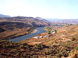
Located on the banks of the Thompson River on Hwy #97C, this former frontier town played key role in the development of central B.C. Once a center for government, Aschroft was also and an important link to the Canadian Pacific Railway. Passengers and freight bound for the Gold Rush communities would disembark and continue their journey on the nearby Cariboo Wagon Road. Later, cattle from the grasslands of the interior would be driven to Ashcroft and shipped south by rail. |
||
|
|
||
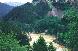
Boston Bar The building of the Cariboo Wagon Road and the CPR railway, formed the foundation of the village that is situated on the steep banks of the Fraser River. During the gold rush, Boston Bar was a popular roadhouse stop. Across the Fraser River from Boston Bar, the CPR built their divisional point at North Bend. In earlier times, an aerial ferry was the only way across the river. Today there's a bridge. Boston Bar, along the Trans Canada Highway # 1 is in the heart of the Fraser Canyon. It is located 42 km (26 mi.) north of Yale and 34 km ( 21 mi.) south of Lytton. River rafting, fishing, gold panning, rock hounding and hiking are very popular past times in this region of British Columbia. |
||
|
|
||
Hope |
||
|
|
||
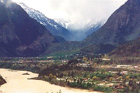
Lillooet At one time Lillooet was the largest settlement in British Columbia. It's importance is evident in that the Mile 0 Cairn that marks the beginning of the famous Cariboo Wagon Road is placed in Lillooet. The cairn was used as a base measure for all the mile posts to the north; i.e. 83 Mile, 100 Mile House, and 150 Mile House. Lillooet is situated on the banks of the Fraser River, and those who arrive from the south either by rail or road will witness awe inspiring views of roaring river canyons and majestic mountains. |
||
|
|
||
|
||
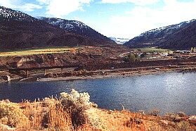
Lytton The blue green waters of the picturesque Thompson River, meet the muddy brown waters of the mighty Fraser at Lytton. This is river rafting country and there are first rate commercial rafting companies ready to take you on a ride of a lifetime. Other interesting activities include hiking, fishing, and rock hounding. Lytton, located along the Trans Canada Highway, is approximately three hours travel time from Vancouver, and only 40 km (25 mi.) from Spences Bridge. If you take Highway 12, it will take you to the historic town of Lillooet, which is only 65 km ( 40 mi.) north of Lytton. |
||
|
|
||
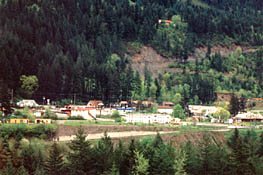
Spences Bridge Spences Bridge is located on Highway #1, 40 km (25 mi.) north of Lytton, where the highway crosses the Thompson River. Spences Bridge is famous for its steelhead fishing and one of the oldest operating hotels in British Columbia, the Steelhead Inn. Travellers passing through in spring and fall are most likely to see herds of big horn sheep on or near the highway. You often have to slow down or stop completely to avoid hitting them. A favourite spot for the sheep is in the school yard - when the students are inside! |
||
|
|
||
|
||
|
|
||
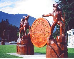
| Yale Located on the banks of the Fraser River was founded in 1848 as a Hudson's Bay Company Fort and played a very important role in the development of British Columbia. Yale was the inland terminus of the sternwheelers plying up the Fraser River. The building of the famous "wagon road" was started here. Just south of town, at Hill's Bar, is the site of the first gold discovered in British Columbia. The documents establishing the Confederation of Canada were signed at Yale. This community is very proud of its historic background and this can be seen when you visit the museum and take the Historic Walking Tour of the town. Yale is only 32 km (20 mi.) north of Hope, on Highway 1. |
||
|
© 1996- INTERACTIVE BROADCASTING CORPORATION Communities in the Fraser River Canyon and Thompson River Canyon |