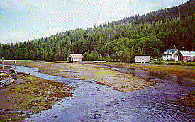
This
small northern coastal community is on Porcher Island about 42 km (26
mi ) south of the port of Prince Rupert. Oona River's history began when
Scandinavian settlers came to homestead this area in the early 1900's.
The community's economic base was centred on the resource industries of
fishing and logging. There have been 102 boats built in Oona River and
there are still boat shops that exist today. The area surrounding Oona
River is combined with oceanic waterways, small coastal inlets and islands
and its proximity to Skeena River.
Accommodation/Adventure
Providers
If you would like to have your business listed, please Click Here.
City
Information
Climate:
Summer Average: 15.5 C • Winter Average: -2.2 C
Precipitation:
236.9 cm/yr
Access:
By boat or seaplane only.
Recreation
Facilities & Activities: Go out fishing for crab, halibut and
salmon, eco-touring, kayak trips to coastal inlets and beaches, view the
local Salmon enhancement project, exploring, hiking areas and trails.
Northern
BC Tourism Association
P.O. Box 2373,
Prince George, B.C. V2N 2S6
Telephone: (250) 561-0432 • Fax: (250) 561-0450
Toll Free: 1-800-663-8843

 This
small northern coastal community is on Porcher Island about 42 km (26
mi ) south of the port of Prince Rupert. Oona River's history began when
Scandinavian settlers came to homestead this area in the early 1900's.
The community's economic base was centred on the resource industries of
fishing and logging. There have been 102 boats built in Oona River and
there are still boat shops that exist today. The area surrounding Oona
River is combined with oceanic waterways, small coastal inlets and islands
and its proximity to Skeena River.
This
small northern coastal community is on Porcher Island about 42 km (26
mi ) south of the port of Prince Rupert. Oona River's history began when
Scandinavian settlers came to homestead this area in the early 1900's.
The community's economic base was centred on the resource industries of
fishing and logging. There have been 102 boats built in Oona River and
there are still boat shops that exist today. The area surrounding Oona
River is combined with oceanic waterways, small coastal inlets and islands
and its proximity to Skeena River. 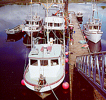 Climate:
Summer Average: 15.5 C • Winter Average: -2.2 C
Climate:
Summer Average: 15.5 C • Winter Average: -2.2 C